
The wider picture
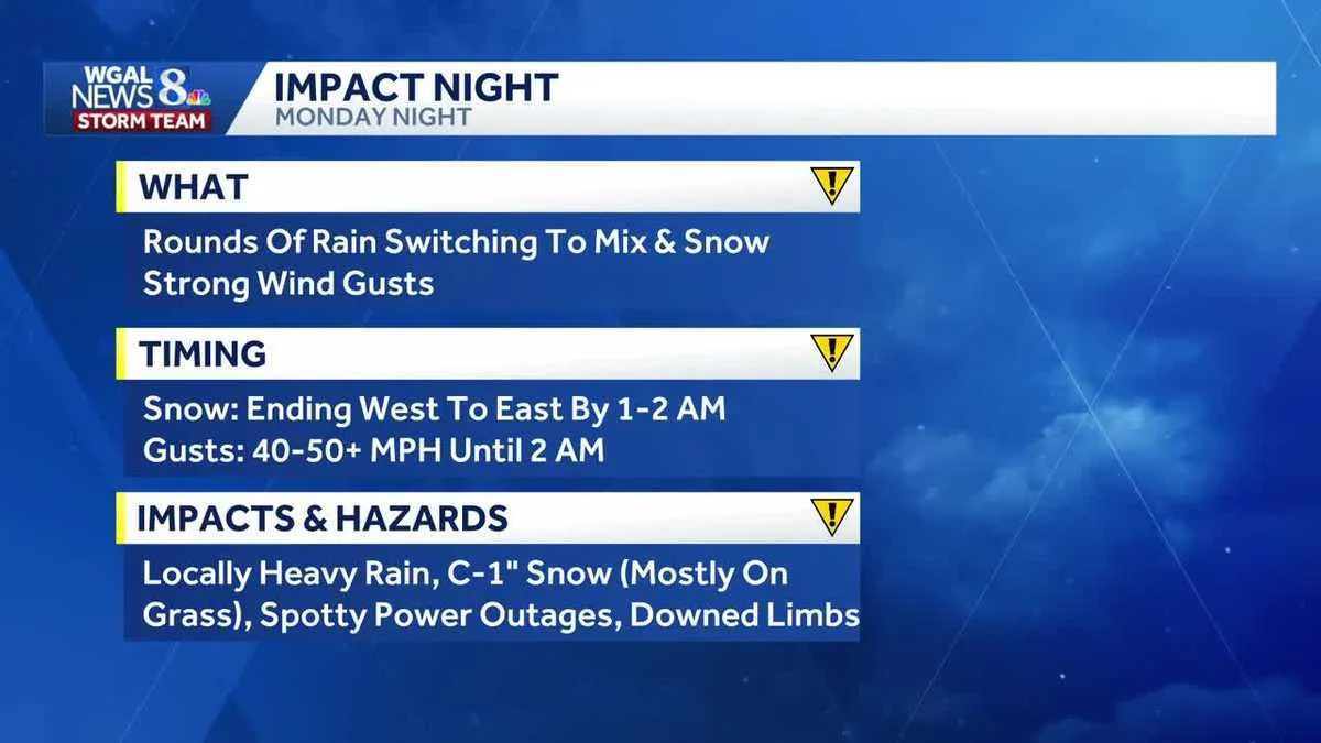
Weather conditions are expected to fluctuate with a cold front passing through Pennsylvania, leading to a significant change in the region’s climate. As the front moves in, residents are experiencing strong overnight rain and high winds, with reports indicating wind gusts in excess of 60 MPH in Lancaster County. This weather system has prompted an active severe thunderstorm warning for the far eastern portions of Lancaster County, which is in effect until 10:30 PM.
As the cold front progresses, temperatures are anticipated to drop into the upper 20s to 30 degrees Fahrenheit as precipitation tapers off. The situation is further complicated by the potential for snow accumulation, with a coating to an inch expected, primarily on grassy surfaces. Observers note that wind chills will make it feel like the teens in the morning of Saint Patrick’s Day, a stark contrast to the milder temperatures that many have enjoyed recently.
Reports from the region indicate that wind gusts have reached as high as 66 MPH in Lancaster, creating hazardous conditions for travel and outdoor activities. The current temperature in Carlisle is around 39 degrees Fahrenheit, while Lewistown is experiencing a chillier 25 degrees. In York, temperatures are slightly higher at 30 degrees, but the wind chill factor is making it feel significantly colder.
In light of these conditions, residents are advised to dress appropriately for the weather, as one local meteorologist stated, “We’re talking wind chills we have to dress for in the teens this morning and 20 this afternoon.” The cold front has certainly made its presence felt, with one observer commenting, “It feels like February for sure.” This dramatic shift in weather is a reminder of the unpredictability of springtime in Pennsylvania.
Looking ahead, temperatures are expected to rise again, with milder weather forecasted to return over the weekend. After the cold front passes, high pressure is anticipated to bring calmer conditions by Friday, allowing residents to enjoy a brief respite from the harsh weather. However, the immediate aftermath of the cold front will still see temperatures remaining below freezing, with road surface temperatures also expected to be low.
As the weather continues to evolve, officials are urging residents to stay informed and prepared for any further developments. The potential for isolated strong thunderstorms remains a concern as the system moves through, with one expert noting, “It’s still an impact night because we have the threat for some isolated strong thunderstorms.” This warning serves as a reminder for all to remain vigilant during this unpredictable weather period.
In summary, the current weather conditions in Pennsylvania highlight the volatility of spring weather, with a strong cold front bringing severe winds, rain, and the possibility of snow. Residents are encouraged to stay updated with local forecasts and prepare for a range of weather conditions as the week progresses. Milder temperatures will return, but for now, the focus remains on navigating the challenges posed by the current system.